Summary According to Met officials, 30 to 40 feet high waves have started rising in the sea due to cyclone
KARACHI (Dunya News) – The sea level started rising in the coastal areas of Karachi and other cities as cyclone Biparjoy nears the land on Tuesday.
As cyclone Biparjoy moved closer, evacuations of a large number of people to safer places at a massive scale from Keti Bandar area in Thatta district started.
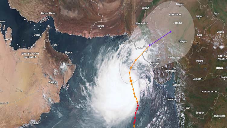
Cyclone Biparjoy, which has been downgraded from extremely severe to very severe cyclonic storm, moved further north-northwestward during the past 12 hours, according to the Pakistan Meteorological Department's (PMD) latest advisory. The main road leading to Chashma Goth has come under water as sea level rises. However, residents of the area have not evacuated their houses despite warnings.
A fisherman said the sea level in Rehrigoth jetty rises in the evenings, submerging part of the jetty.
According to Met officials, 30 to 40 feet high waves have started rising in the sea due to the cyclone. At present, the storm is heading towards Gujarat, India.
On the other hand, the Met Department forecast that the weather is likely to remain humid and hot in Karachi under the influence of the cyclone. There are chances of dust raising winds and thunderstorm in the afternoon.
It stated that the cyclone has now moved to about 470km south of Karachi and 460km south of Thatta, at a latitude 20.7°N and longitude 67.1°E.
The PMD stated that maximum sustained surface winds are 140-150km/hour gusts 170km/hour around the system centre, and sea conditions are "phenomenal" around the system centre with a maximum wave height of 30 feet.
The favourable environmental conditions (sea surface temperature of 29-31°C, low vertical wind shear, and upper-level divergence) are in support of sustaining its strength through the forecast period.
Under the existing upper-level steering winds, the cyclone is most likely to track further northward until the morning of June 14, then recurve northeastward and cross between Keti Bandar (Southeast Sindh) and Indian Gujarat coast on June 15 afternoon as a very severe cyclonic storm with packing winds of 100-120Km/hour.