Summary Google took to the sands to expand its globe-spanning Street View imagery, using its Trekker camera
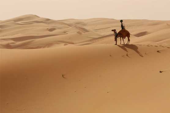
LIWA: (Dunya News) - Google took to the deserts to expand its Street View imagery, using its Trekker camera mounted to an actual camel’s hump to capture photos from the Liwa Desert, a pristine wonderland straight out of fantasy tales in the United Arab Emirates (UAE). Camel was used in order to avoid causing any change in the natural atmosphere of the area, which has been habilitated, unchanged, since the Late Stone Age.
Google has used Trekker-Pack on a camel back in order to penetrate the areas which its cars can simply not penetrate. These cameras can only be worn and carried by human hosts, not dromedaries. Previously, the same trekker pack was used by Google to map the Grand Canyon, the wild northland of Canada, and other places for improving its street-view imagery. These cameras have previously been used and are not at all difficult to carry. They are light enough to be carried by humans so a camel carrying them isn’t going to be an issue.
The images that this trekker pack has brought with it are simply stunning and are from a place where one may only have a remote chance of visiting. But that is why the street-view thing was created by Google. The combination of high-tech imagery equipment with an age-old means of conveyance is just icing on the cake.