Summary Chief meteorologist says 60-80kmph winds may hit port city
KARACHI (Duny News) - Evacuations have begun in the coastal areas of Sindh as Cyclone Biparjoy inched closer to the province’s coastal belt on Tuesday.
Pakistan Army troops aided by the civilian government are in the process of evacuating residents of the country's coastline and removing movable structure ahead of "Cyclone Biparjoy" that is hardly 470 kilometres away from Karachi.
Triggered by the cyclone, torrential rains are also expected anytime in Karachi, Hyderabad and other parts of Sindh.
Chief Minister Murad Ali Shah on Monday announced that 32,466 people in the districts of Sujawal, Badin and Thatta, as well as residents of around 70 buildings in Karachi were vulnerable to the cyclonic storm.
The Pakistan Meteorological Department (PMD), in an official statement, states that the tropical cyclone has intensified into an ‘Extremely Severe Cyclonic Storm’ - Category 3, with sustained wind speed of approximately 161 to 180 km per hour and gusts up to 200 km per hour. Its current location is roughly 470 km south of Karachi and 460 km south of Thatta.
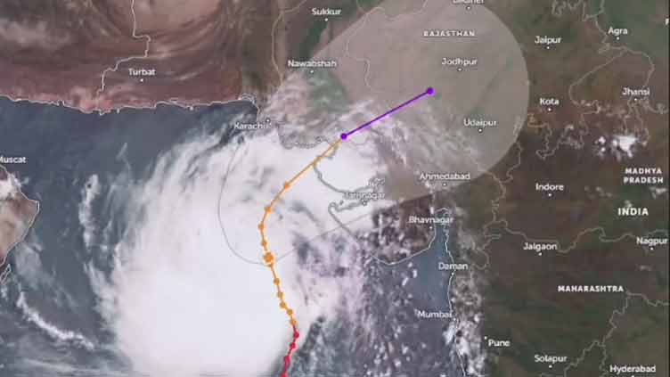
The cyclone is expected to maintain a northward trajectory till tomorrow and then re-curve Eastward towards Keti Bandar and Indian Gujarat Coastline as a very severe cyclonic storm.
The Extremely Severe Cyclonic Storm (ESCS) over northeast Arabian Sea moved further north-northwestward during last 12 hours, weakened into a Very Severe Cyclonic Storm (VSCS) and now lies near Latitude 20.7°N & Longitude 67.1°E at a distance of about 470km south of Karachi, 460km south of Thatta.
Maximum sustained surface winds are 140-150 Km/hour gusts 170 Km/hour around the system center and sea conditions being phenomenal around the system center with maximum wave height 30 feet. The favorable environmental conditions (sea surface temperature of 29-31°C, low vertical wind shear & upper-level divergence) are in support to sustain its strength through the forecast period.
Under the existing upper-level steering winds, the VSCS “BIPARJOY” is most likely to track further Northward until 14 June morning, then recurve Northeastward and cross between Keti Bandar (Southeast Sindh) and Indian Gujarat coast on 15 June afternoon/evening as a Very Severe Cyclonic Storm (VSCS) with packing winds of 100-120Km/hour. PMD’s cyclone warning center, Karachi is continuously monitoring the system and will issue update accordingly.
The areas likely to be affected by the cyclone include Thatta, Badin, Sajawal, Tharparkar, Karachi, Mirpurkhas, Umerkot, Hyderabad, Ormara, Tando Allah Yar Khan and Tando Mohammad Khan.
The National Disaster Management Authority (NDMA) in its update on its Twitter handle says the movement of the cyclone is being monitored continuously to face possible danger and tackle its effects.
NEOC Update #CycloneBiparjoy weakened into a Very Severe Cyclonic Storm,with w/speed of approx 140-150 km/h, 470 km South of Karachi,460 km of Thatta. It's evolving sit&impact will only be certain w/further dev of sys.https://t.co/TBWt0ziBw5
— NDMA PAKISTAN (@ndmapk) June 13, 2023
Source:Zoom Earth. NASA World View pic.twitter.com/JyUlG6o8dU
-- Possible Impacts --
With its probable approach to the southeast Sindh coast, widespread wind-dust/thunderstorm rain with some very heavy/extremely heavy falls accompanied with squally winds of 80-100Km/hour gusting 120km/hour likely in Thatta, Sujawal, Badin, Tharparker, Mirpurkhas & Umerkot districts during 13-17 June.
Dust/thunderstorm-rain with few heavy falls and accompanied with squally winds of 60-80 Km/hour likely in Karachi, Hyderabad, Tando Muhammad Khan, Tando Allayar, Shaheed Benazirabad & Sanghar districts from 14 -16 June.
Squally (high intensity) winds may cause damage to loose & vulnerable structures (Kutcha houses) including solar panels etc.
Storm surge of 3-3.5 meters (8-12 feet) expected at the land falling point (Keti Bandar and around) which can inundate the low-lying settlements.
Fishermen are advised not to venture in open sea till the system is over by 17 June, as the Arabian Sea conditions may get very rough/high accompanied with high tides along coast.
-- Pak Army troops deployed --
Pakistan Army toops have been deployed along the coastal areas to meet any untoward and unexpected situation. The decision to deploy troops was taken at a meeting participated by Sindh Chief Minister Murad Ali Shah, the Pakistan Rangers (Sindh) director-general and the Hyderabad Garrison GOC.
Troops have been dispatched to the coastal areas.
-- PM Shehbaz lauds Sindh CM for adopting safety measures --
Prime Minister Shehbaz Sharif on Monday lauded the Sindh government’s efforts for taking preemptive measures to avert the cyclone “Biparjoy”, that is now 530 kilometers away from the Sindh coast.
Taking to Twitter, the PM wrote that he "commended" Sindh's government's arrangements, and assured the federal government's complete support in this regard.
— Shehbaz Sharif (@CMShehbaz) June 12, 2023
Authorities have swung into action and started immediate evacuation process and closure of residential and beaches along the coastline as the cyclone "Biparjoy" is likely to hit Pakistani shores in hours to come.
The cyclone, now classified as an “extremely severe cyclonic storm” by the Pakistan Meteorological Department (PMD), was around 600km away from Karachi, 580km south of Thatta, and 710km southeast of Ormara, after moving further northward during the last 12 hours.
The Sindh government began the evacuation drive from the coastal areas of Badin, moving the residents to safe places in order to avoid any loss of life.
Sindh Chief Minister Murad Ali Shah visited Shah Bandar area of the district and later chaired a meeting to review arrangements for mitigating the impact of Biparjoy in the coastal belt at 31 Creek Conference Room in Sujawal.
— Sindh Chief Minister House (@SindhCMHouse) June 12, 2023
The government had decided to evacuate the residential areas and other human settlements near the coast of Sindh as the risk of tropical cyclone Biparjoy present in the Arabian Sea escalates.
#CycloneBiparjoy https://t.co/R3UbInfpYA
— NDMA PAKISTAN (@ndmapk) June 12, 2023
The authorities have repeatedly warned the citizens to beware of the gravity of situation. However, warnings fell on deaf ears as people continue to entertain themselves at sea shores.
In its latest Tweet, the National Disaster Management Authority (NDMA) says Biparjoy is now an extremely severe cyclonic storm.
— NDMA PAKISTAN (@ndmapk) June 12, 2023
Earlier, the authority issued a warning to the public, urging them to stay away from shorelines as Cyclone Biparjoy approaches the coastal areas of Pakistan and India. The cyclone is currently located approximately 690 kilometres south of Karachi.
— NDMA PAKISTAN (@ndmapk) June 11, 2023
The NDMA directed the authorities concerned to run awareness campaign in local language to inform residents of the coastal areas on weather conditions and advise them against visiting the shorelines.
“Fishermen should avoid boating in the open sea. Follow and cooperate with local authorities in emergency situation,” it added.
State-run Radio Pakistan reported that the NDMA advised people to follow the guidance of local authorities in case of any emergency situation. The Karachi commissioner has already imposed a ban on beach access, fishing, sailing, swimming, and bathing within Karachi’s territorial limit due to the potential threat from the cyclone.
Despite the government’s directives, a significant number of people were observed at Karachi’s Sea view, defying the orders to stay away from the shore. However, the police authorities say even there are restrictions on swimming and fishing in the open sea, there are no limitations on visiting the beach.
The Pakistan Meteorological Department (PMD) has officially declared Cyclone Biparjoy as an “extremely severe cyclonic storm.” It is currently situated around 690 kilometres south of Karachi.
The PMD predicts that the cyclone will track further northward until the morning of June 14 before re-curving north-eastward and making landfall between Keti Bandar (southeast Sindh) and the Indian Gujarat coast on June 15 as a “very severe cyclonic storm.” The cyclone is accompanied by maximum sustained surface winds of 150-160 kilometres per hour and gusts of up to 180 kilometres per hour near the centre. Sea conditions are described as “phenomenal” with maximum wave heights reaching 35-40 feet.
The Pacific Disaster Centre (PDC) reported that approximately 1.38 million people from both Pakistan and India are exposed to the cyclone, with 305,755 among the vulnerable population. The PDC forecasts sustained winds of 185 kilometres per hour with gusts up to 232 kilometres per hour.
The PMD has issued warnings about the potential impacts of the cyclone. It predicts widespread wind-dust/thunderstorm rain with heavy falls and squally winds of 80-100 kilometres per hour in Thatta, Sujawal, Badin, Tharparker, and Umerkot districts from June 13 to 17.
Karachi, Hyderabad, Tando Muhammad Khan, Tando Allayar, and Mirpurkhas districts are likely to experience dust/thunderstorms, rains with occasional heavy falls and squally winds of 60-80 kilometres per hour from June 13 or 14 to 16. The PMD advises fishermen to avoid venturing into the open sea until June 17, as the Arabian Sea conditions are expected to become rough with high tides along the coast.
Sindh Chief Minister Murad Ali Shah assured that the government is fully prepared to handle the potential impact of the cyclone. The CM mentioned that the cyclone’s projected path has shifted away from Karachi but identified Thatta, Badin, Sujawal, and Badin as areas at risk. Preparations are being made to evacuate vulnerable families and secure loose structures in those districts.
The public has been urged to avoid beaches during the cyclone, and the government is closely monitoring the situation and providing assistance where needed.
The authorities remain vigilant and prepared for any outcome, emphasizing the importance of caution and planning in dealing with the cyclone’s potential effects.
All depts in Sindh and Balochistan should be on high alert. #BiparjoyCyclone is unpredictable yet categorised as high intensity. Panic is counterproductive but caution and planning are better than being caught unawares. @ndmapk @pdmasindhpk @PDMABalochistan pic.twitter.com/Bd2W3YDdgx
— SenatorSherryRehman (@sherryrehman) June 11, 2023
“#Biparjoy Cyclone is unpredictable yet categorised as high intensity. Panic is counterproductive but caution and planning are better than being caught unawares,” tweeted Minister for Climate Change and Environmental Coordination Sherry Rehman, advising all relevant departments of Sindh and Balochistan to be on ‘high alert’.
-- Sindh mulls evacuation today --
The Sindh government has decided to evacuate the residential areas and other human settlements near the coast of Sindh.
All the authorities concerned have been put on high alert as Biparjoy continues to gain strength after turning into an Extremely Severe Cyclonic Storm (ESCS), likely to affect Sindh’s coastal areas on June 15 (Thursday).
Keeping the risk in view, the decision to evacuate areas was taken on Sunday in a meeting chaired by Karachi Commissioner Iqbal Memon, where the participants discussed the preemptive measures regarding the cyclonic storm.
The meeting was attended by Sindh Chief Meteorologist Sardar Sarfaraz, alongside other relevant officials.
The authorities concerned have been directed to implement the evacuation plan in coordination with the Provincial Disaster Management Authority (PDMA) by tomorrow (June 13), when the storm is likely to hit the coast.
-- Gwadar plans to tackle cyclone --
The Balochistan Provincial Disaster Management Authority (PDMA) has also devised a plan to tackle the rising threat of the cyclone in the coastal area of Balochistan, and more steps are being taken.
It was decided to declare an emergency in the hospitals on an emergency basis and imposed a complete ban on going to the coastal area.
The district administration has also directed a ban on fishing, and fishermen were advised not to venture into the open sea during rough conditions and to remain extra cautious during the forecast period.