Summary Scientists can make forecasts about future of climate change with Antarctica's topography info
(Web Desk) - A group of scientists and engineers has embarked on an Antarctic mission to trial an autonomous drone designed to enhance climate change impact forecasting.
This cutting-edge drone is set to explore previously inaccessible regions of the continent, overcoming challenges posed by extreme weather conditions.
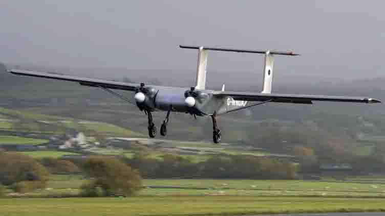
Having undergone rigorous testing amid the harsh weather conditions around Wales' highest peaks, the drone is primed for its primary task – mapping areas beneath an ice sheet in Antarctica. This initial experiment aims to predict the rate of ice melt and its contribution to global sea-level rise.
Antarctica, a critical area for climate research, presents formidable obstacles to traditional crewed planes due to strong winds, sub-zero temperatures, sudden storms, and prolonged periods of darkness.
These challenges, coupled with the logistical complexities of transporting pilots and substantial amounts of fuel, have hindered scientific exploration.
Developed by the British Antarctic Survey in collaboration with UK-based company Windracers, the autonomous drone boasts easy repair capabilities in case of malfunctions.
Prior to its Antarctic mission, the drone underwent testing in the challenging weather and terrain of Llanbedr, Eyreri (Snowdonia in English) in North Wales.
Engineer Rebecca Toomey, explaining the drone's capabilities during a practice run in adverse conditions, highlighted its capacity to access remote areas without compromising pilots' safety.
This innovative technology holds the promise of revolutionizing scientific exploration in Antarctica, providing valuable insights into the dynamics of climate change in the region.
Rebecca will be in charge of operating the drone from the Rothera base in Antarctica, with future aspirations for the British Antarctic Survey to control it remotely from the UK.
This innovative drone significantly reduces fuel consumption compared to traditional planes, with only 10 barrels used in contrast to the 200 barrels typically required for a single research flight.
This advancement aligns with a commitment to minimizing the environmental impact of scientific endeavors on the planet.
Antarctica's expansive ice sheets encompass vast mountain ranges, some rivaling the size of the European Alps, along with deep trenches and valleys, with certain areas situated below sea level.
Understanding this intricate topography is crucial, as it directly influences the speed at which the ice melts. By gaining a more comprehensive understanding of Antarctica's landscape, scientists aim to enhance the precision of predictions related to global sea-level rise resulting from ice sheet melting.
Tom emphasizes that with improved knowledge of Antarctica's topography, scientists can make more accurate forecasts, ultimately aiding in future planning efforts.
The inaugural drone flights are scheduled for the coming weeks, featuring additional experiments such as surveys of marine life, including krill, essential components of the food chain, and assessments of environmentally sensitive areas.